A suite of complementary services aimed squarely at providing customer value for the telecommunications sector.
Members of the Mantra Services team have been working in the telecommunications sector since the 1990s in an array of roles from survey and design to project delivery.
Working with rollout service providers and network operators in the marketplace, Mantra provides support services across acquisition and planning, design, construction, temporary sites, decommissioning and handover.
With decades of telecommunications sector experience and competency, our in-house resources have acquired a range of operational and commercial skills offering the ability to solve multiple problems for the customer, often all at once.
This multidisciplinary approach allows efficiency and cost savings to the client by undertaking different operations in a single visit or multiple sites tasks being allocated under managed programme roll out where this can be arranged.
Utility Searches
A utility search is undertaken for all sites where an excavation has to be undertaken. The searches are often the starting point for trial hole excavations and designers use this collected information for the location of equipment.
As a fundamental element in all new sites, a client simply needs a supplier to deliver the information quickly, in a format they need and at a sensible cost.
In the telecommunications sector, the collected service information is often transposed into CAD so designers can use the information easily.
In our experience, other providers do not always incorporate all the relevant information received with a search. At Mantra we interrogate all data received from utility asset owners including cross-sectional data and manhole schedules to make sure we provide the best possible dataset to the customer.
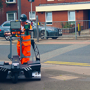
GPR Surveys
Some telecommunications projects will require a utility survey with EM and GPR equipment to provide an additional layer of information beyond what can be achieved with searches alone. For some locations such as street works, this becomes an essential requirement. A utility survey provides a next-level set of data not achievable with any other non-intrusive method.
At Mantra, in accessible locations such as street works sites, we deploy our IDS Stream GPR unit. This multi-antenna array provides the best possible GPR data. The unit has 32 channels surveying a footprint on 960mm wide with each pass, with no gaps in the data. This allows our geophysics team to interrogate the data accurately in 3d dimensions, a benefit not available to other, more traditional, GPR systems.
The GPR survey can be undertaken in conjunction with utility searches. This is the most effective approach, with a single, final set of CAD data passed onto designers for use, alongside the search report.
In addition, the survey can be undertaken alongside trial hole excavations. This collaborative methodology allows our teams to help direct the civils operatives to excavate in the relevant locations making the process more efficient and providing final drawings to include physically identified service locations.
CAD
Like most of the construction industry, the telecommunications sector relies on accurate and up to date CAD information in every stage of the project.
Whatever the survey being undertaken, as a business, Mantra delivers CAD information as the final product in almost everything we do. Therefore, we always use the latest releases of applications in the Autodesk suite of products including AutoCAD, Revit and Recap.
As part of your design team or as a backup to existing CAD resources, outsourcing some or all of the CAD requirement is a cost-effective alternative to keeping a CAD team in house.
You can procure services on an as-needed basis. This removes the requirement for expensive software licenses, high-end hardware costs and staff costs from the overhead.
For existing sites where equipment is being upgraded, particularly complex rooftop installations, the Autodesk suite of applications, combined with a 3D laser scanning survey can provide the most accurate information available for designers and planners to base their decisions.
Millions of scanned points create a 3D digital representation of a site, allowing detailed drawings to be produced at an accuracy unavailable with any other method.
Panoramic Photography
As part of the planning and design process for sites, a panoramic photography survey is undertaken. This provides cell planners with the required line of sight analysis to determine the suitability of a location for a new site.
High-quality photography coupled with accurate locational and directional data is crucial to the customer, giving decision-makers confidence in the data they are using.
Mantra uses survey-grade GPS for location information. This provides centimetre accuracy in the three dimensions of the x,y and z coordinates.
This can be presented in any coordinate system required, such as WGS84 (latitude and longitude) or OSGB35 (eastings and northings), or in multiple all at the same time.
Panoramic photography can be taken up to 10m with a handheld device or up to 20m with the vehicle-mounted solution.
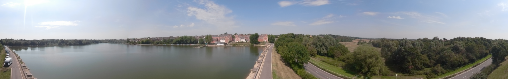
The handheld device provides quick and easy deployment for lower height ranges with the vehicle system offering a more stable approach at height.
Photography can be with a digital SLR or with a 360-degree camera depending on the customer requirements.
Our panoramic survey may be able to be undertaken at the same time as a GPR survey. This passes on a cost-benefit the client no other service provider can offer
Commercial Management
The key to the success of any business is the effective management of commercial activities. This is at the very core of the services provided by Mantra and the knowledge base accrued with 30 years of telecommunications sector experience provides the skill set to deliver that success on behalf of the client.
The Mantra team can offer estimating and quantity surveying expertise in day to day roll out of infrastructure, supplier procurement, contract analysis and commercial troubleshooting on an ad-hoc or long-term basis.
As part of our commercial support function, we offer a review of contract terms and conditions to provide a commercial risk and opportunity matrix which is implemented and managed through the lifecycle of the project to enable efficient commercial management and administration of a contract.
Our commitment to the customer remains the same. The commercial success of our clients is directly related to our own.